
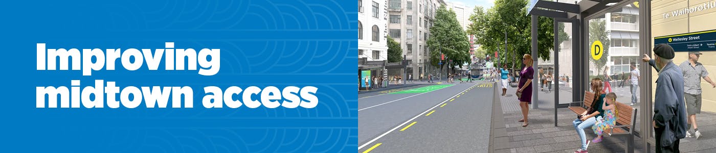
Midtown Access Trial
Access to Midtown is changing from Sunday 19 April 2026
Midtown is getting ready for a busy year. With the Wellesley Street bus upgrades nearly finished and Te Waihorotiu Station opening later this year, more people will be travelling through the city centre.
To get ready, we’re trialling changes that support bus reliability, pedestrians, and access for businesses and residents, while improving evening and mobility access and connections to key destinations.
The trial will run for up to two years. This gives us time to monitor what’s working, understand the impacts, and adjust the changes if needed.
We’ll contact you in July 2026 to ask how the changes are working once the trial has had time to settle in. Your feedback will help shape what happens next. Register to be involved.
Thanks to everyone who shared early feedback. Auckland Council’s Traffic Control Committee considered it before recommending the trial go ahead. Read a summary of what we heard.
Sign up for updates to the Midtown Access Trial or to join the Midtown Advisory Group
What is changing to how I get around?
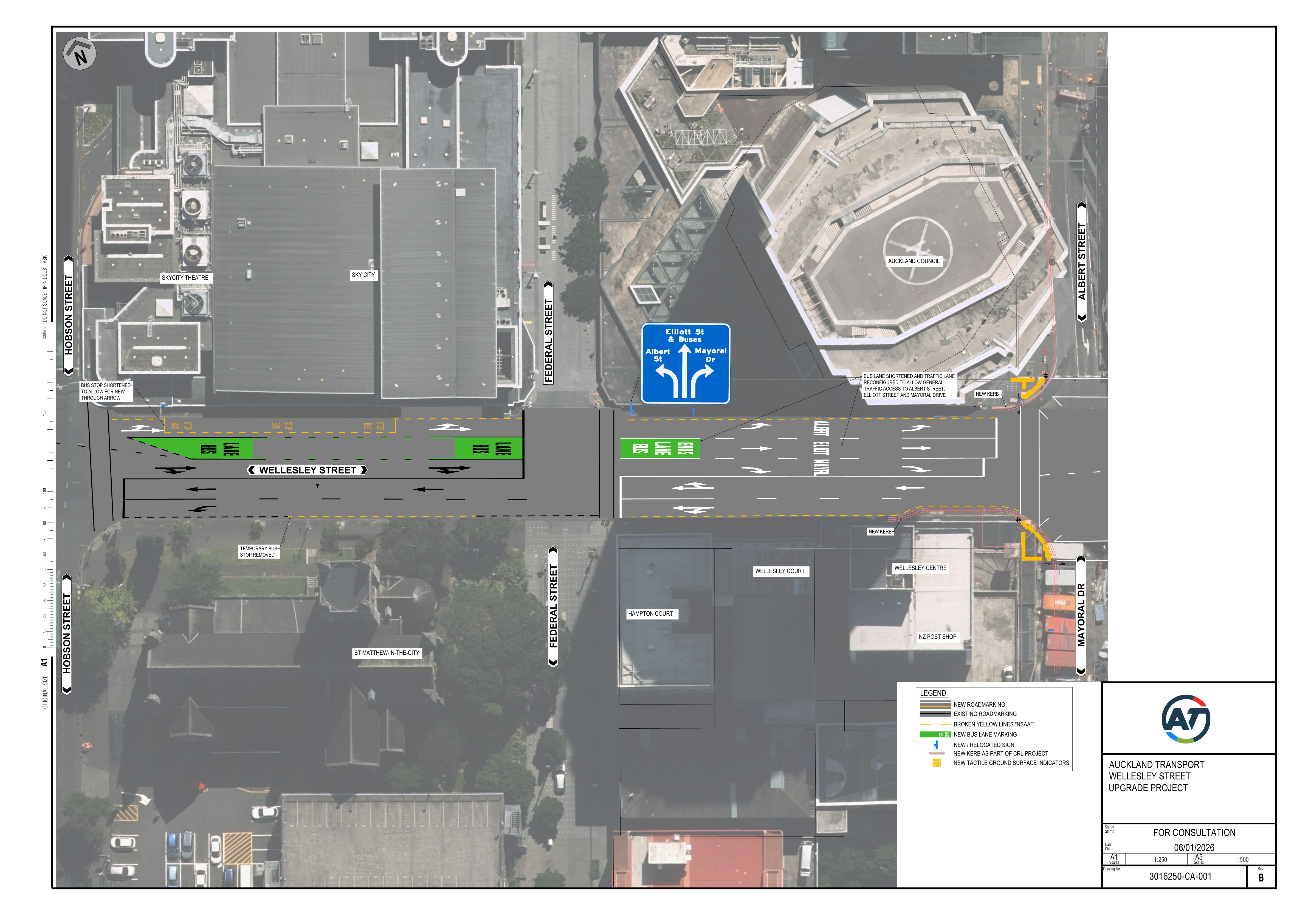
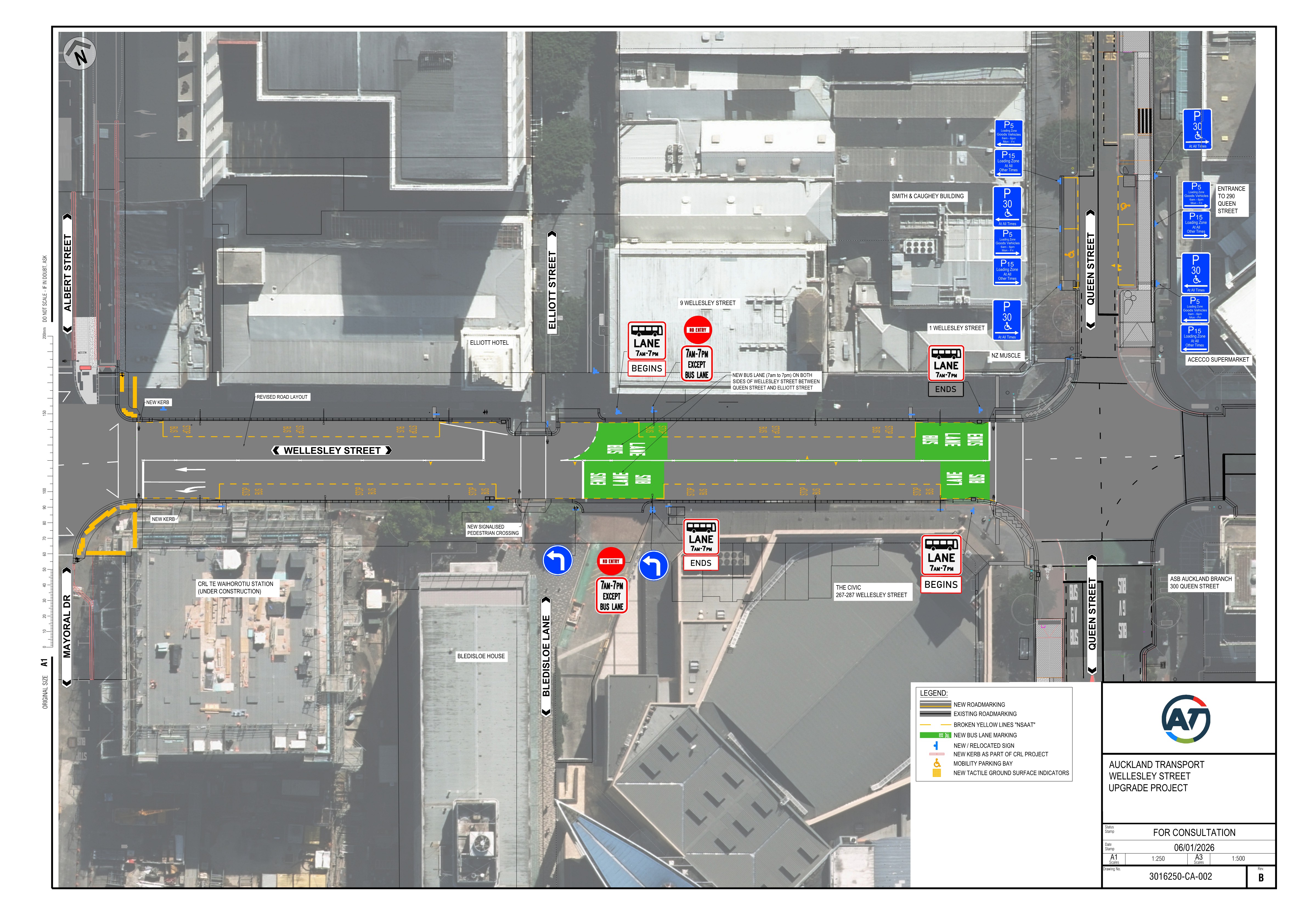
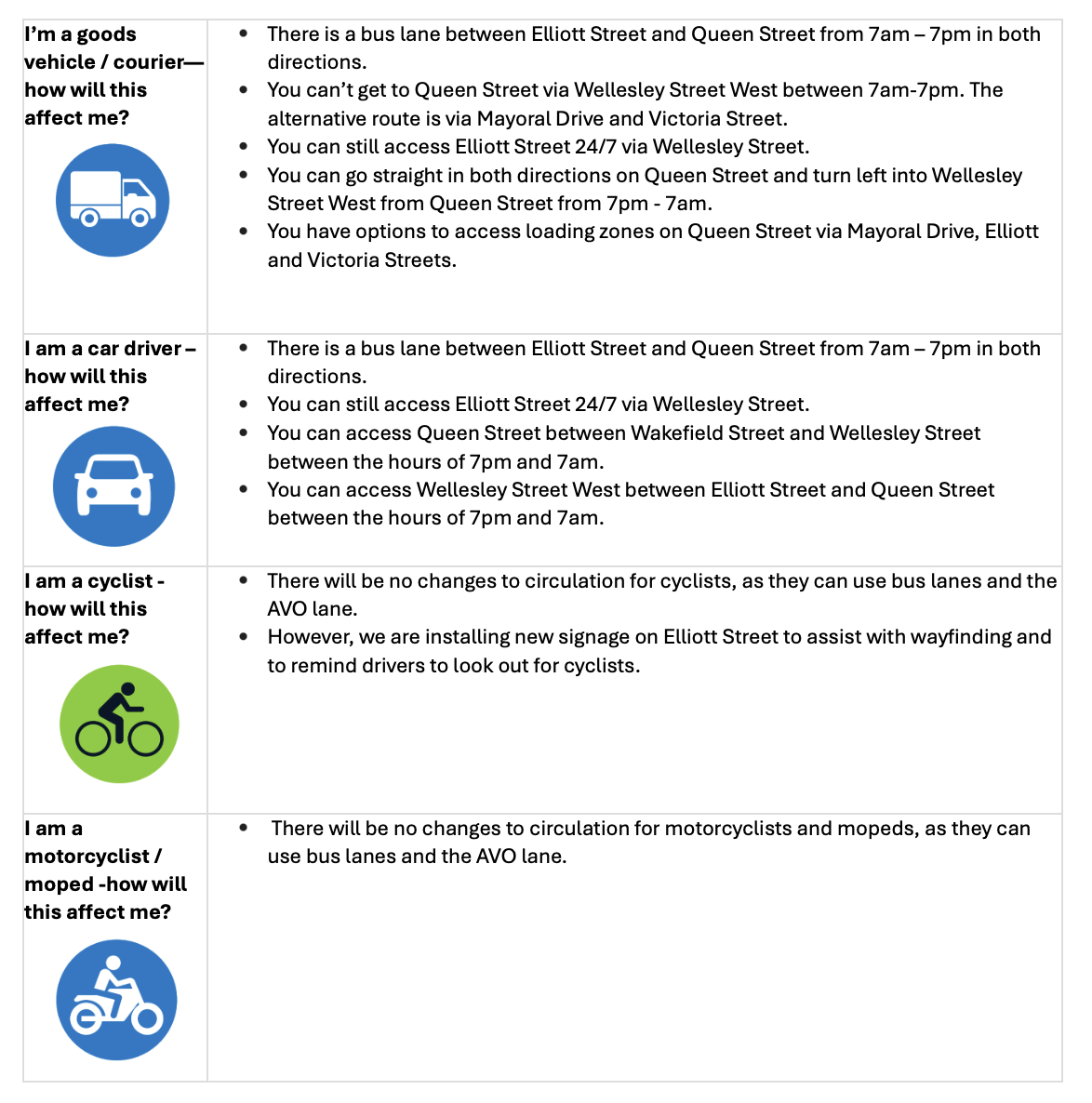
Wellesley Street (between Elliott Street and Queen Street)
Bus lanes operating 7am to 7pm daily
Access to local businesses, the two public carparks and motorcycle parking on Elliott Street via Wellesley Street will continue.
Preferred routes for general traffic traveling through Midtown are Mayoral Drive and to a lesser extent Victoria Street.
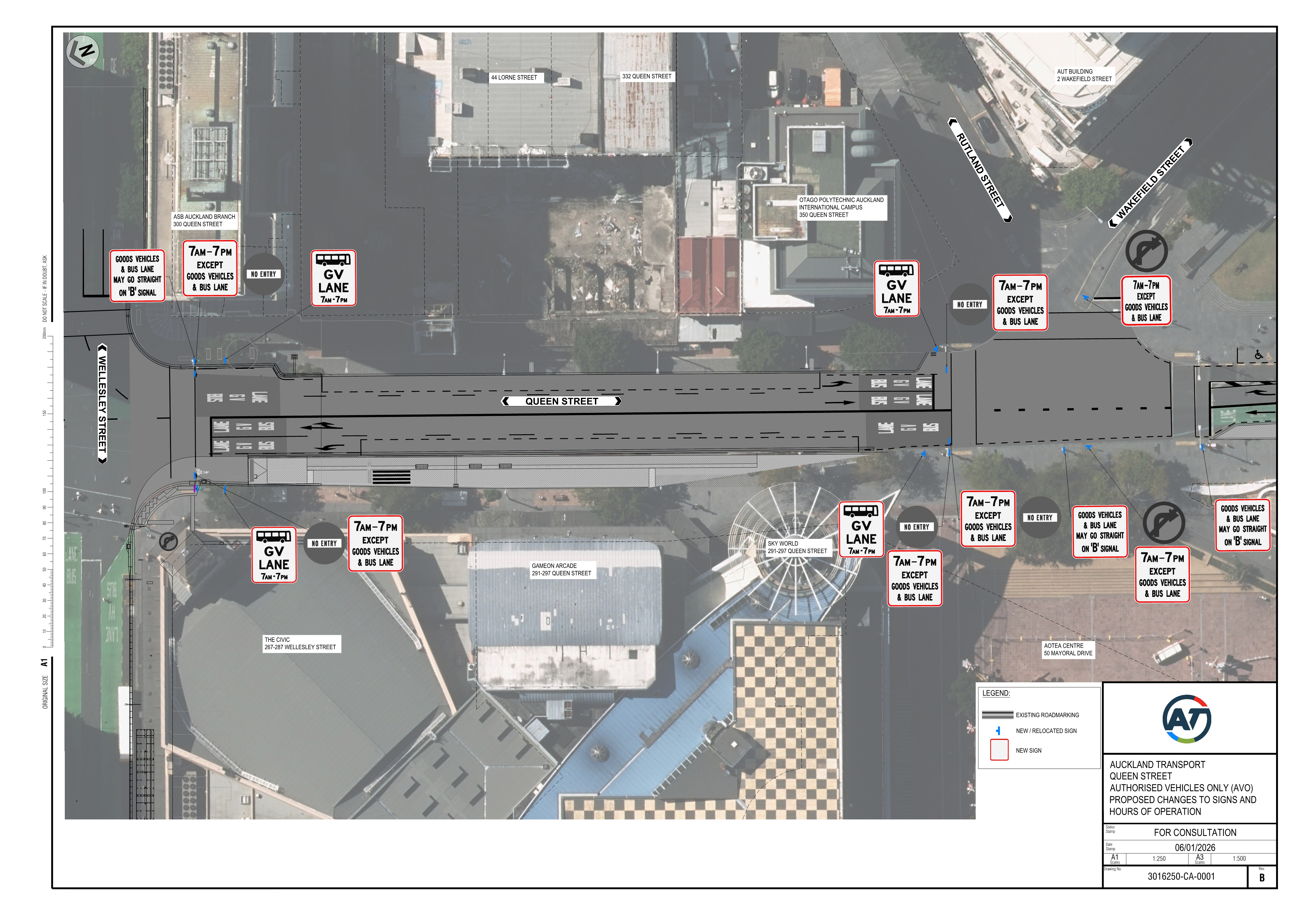
Queen Street (between Wakefield Street and Wellesley Street)
- Goods Vehicles & Bus lane operating between 7am to 7pm daily instead of 24 hours a day.
- After 7pm all vehicles will be able to travel along this section, improving evening access to arts and entertainment destinations.
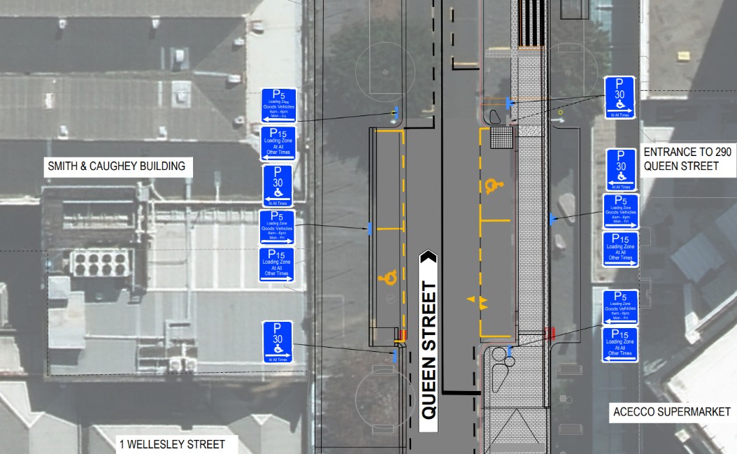
- Loading zones outside Acecco Supermarket and the Smith & Caughey Building will be limited to 5 minutes on weekdays between 6am to 6pm. At all other times it will be for 15 minutes.
- Mobility parking outside 290 Queen Street will be 30 minutes on both sides of the street.
- New dedicated pick up and drop off locations enhancing in Wakefield Quadrant enhancing access to key Midtown destinations i.e. the Town Hall and the Civic Theatre.
Total Mobility
Total Mobility registered vehicles will be permitted to use the Goods Vehicles & Bus lanes on Queen Street during the trial operating hours (daily, 7am–7pm) to access mobility parking on Queen Street. This change represents a positive step toward improving accessibility in the city.

What's happening on Wellesley Street?
Wellesley Street upgrades are close to completion, with new bus shelters, wider footpaths and safer crossings. When Te Waihorotiu Station opens, more people will be walking to and from the station and catching buses on Wellesley Street. Further changes are needed to support Wellesley Street as a key gateway to the city and a thriving pedestrian and entertainment destination.
From Sunday 19 April 2026:
Bus lanes will operate between Elliott Street and Queen Street (7am–7pm daily). These lanes will prioritise buses from 7am to 7pm daily to enable faster, more reliable journeys.
From 7pm to 7am daily, these bus lanes are open for general traffic to reach Queen Street when bus travel is less frequent.
Between 7am and 7pm, only buses, bikes, motorbikes and mopeds can use the bus lanes
What is Happening on Queen Street?
Goods Vehicles & Bus lane (Wakefield Street to Wellesley Street)
Albert Street and Mayoral Drive reopened in November 2025 after eight years, bringing back nearly 900 buses daily. This shifted 447 buses each way from Queen Street, where they ran during construction.
As streets are upgraded and re-opened and the city evolves, how we move around will continue to change. The council group are shifting focus towards optimising our integrated city centre transport network post-construction.
On Queen Street (between Wakefield Street and Wellesley Street) there is currently a 24/7 bus lane and Authorised Vehicles Only (AVO) lane. Find out more about vehicles that can use an AVO.
These lanes have had a few different names over the years, including the Essential Vehicle Area (EVA) and the Authorised Vehicles Only (AVO) zone. To keep things simple and match what you’ll see on street signs, we’ll call them Goods Vehicles & Bus lanes.
Goods Vehicles & Bus lane hours will change from 24/7 to 7am–7pm
During the trial, the Goods Vehicles & Bus lane operates 7am–7pm, every day. After 7pm, all vehicles can use this section.
Mobility access (Total Mobility and mobility parking)
Total Mobility is a New Zealand-wide scheme that supports people with mobility access needs by offering subsidised fares on participating taxis. As part of the trial, Total Mobility registered vehicles can use the Goods Vehicles & Bus lane during operating hours (7am–7pm daily) to reach mobility parking.
Mobility parking is located outside 290 Queen Street, just north of Wellesley Street.
Take a closer look at the drawings here
Loading Zone Changes
The timing of the existing Loading Zone (LZ) spaces on both sides of Queen Street—just north of Wellesley Street, outside Acecco Supermarket and the Smith & Caughey building—will be adjusted.
These changes in time will align with the majority of LZ times in the city centre, at 5 minutes (Monday to Friday, 6am to 6pm), to increase turnover and improve availability for service vehicles during busy periods.
After 6pm on weekdays and throughout weekends, loading and pick-up/drop-off activities become a higher priority. To accommodate this, the vehicle loading time will be extended to 15 minutes.
Take a look at the drawings here
Why is this a trial
We’re taking a pragmatic, balanced approach that reduces obstacles for visitors, businesses and residents, supports key destinations and the night-time economy, and monitors the changes so we can adapt where needed. These changes are being delivered as a trial under the Land Transport Rule: Streets Layout 2023.
The trial will last for up to two years, giving us time to learn what works and where adjustments may be needed. This timeframe also allows for meaningful input before any decisions are made about making changes permanent.
Quarterly reviews
We’ll review the trial every three months and share updates on what we’re seeing. We will be collecting a range of operational data - including bus travel time, pedestrian safety, traffic volumes, compliance, servicing activity, and feedback from landowners, residents, businesses, and visitors.
We’ll gather feedback through surveys, conversations, and direct engagement with stakeholder groups.

Midtown Advisory Group
We’re setting up a new forum – the Midtown Advisory Group – to ensure a wide mix of people and organisations can be involved. This group will help shape the trial by sharing insights, providing feedback, and reviewing results.
We welcome both individuals and groups to apply. Each quarter, we’ll share the trial results with the Advisory Group for discussion and comment. Our goal is to make the evaluation process collaborative, transparent, and reflective of the community’s experience of the changes. Register your interest for the Midtown Advisory Group.
Managing parking on Elliott Street's shared spaces
Elliott Street has been a shared space since 2011.
With works on Wellesley Street nearing completion and the CRL opening later this year, loading zone times will revert to standard shared‑space operating hours from Sunday, 19 April.
What this means for you
On-street loading and servicing will change from 6am-6pm to 6am - 11am
From 11am-6am no stopping will be permitted except in dedicated Loading Zones.
Access to local businesses, the two public carparks and motorcycle parking on Elliott Street via Wellesley Street will continue.
We are working to deliver a solution that helps Elliott Street be a safe, welcoming shared space in our city centre while supporting business operations. We are therefore planning on introducing three additional spaces. Two on Elliott Street and one on Darby Street. These would be operational at all times. We will let you know when the additional Loading Zones will be operational.
New Traffic Circulation
Thank you for your questions and feedback on Midtown circulation and access changes. Engagement on this project is now closed.

Signup Banner

Thank you for your contribution!
Help us reach out to more people in the community
Share this with family and friends