
FAQs
- Route 65: Runs between Pt Chevalier and Glen Innes. Stops at key places like St Lukes Mall, Greenlane Train Station, and Glen Innes Train Station.
- Route 321: Runs from Britomart to Middlemore Station via Greenlane Hospital. Connects Auckland City Hospital, Greenlane Hospital, and Middlemore Hospital.
- School Route 418: Runs from Balmoral to Sacred Heart.
- There are up to 8 buses an hour in each direction on this road along with school buses and private hospital shuttles.

- Patronage on route 65 has increased by around 60% since the route was upgraded in November 2025, with the highest month up by 75%. Click here for more information.
Why Green Lane West and what does it mean for me?
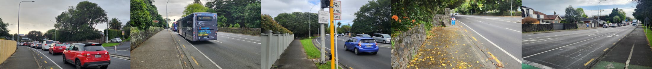
Green Lane West is one of Auckland’s busiest roads, carrying up to 25,000 vehicles and 70,000 bus trips in its busiest month. It is home to well-known destinations like Cornwall Park, Greenlane Clinical Centre and Auckland Showgrounds, and the area is growing quickly with new housing developments.
Congestion is a real challenge here. Average speeds drop to 15 km/h in the morning rush and 20 km/h in the afternoon. Passenger numbers are growing fast, and while peak times are busy, there’s still room for more people. Cycling is possible, but narrow lanes and limited space make it tough.
We’re proposing changes for improved bus journeys and a layout that can adapt as the community grows. Our goal is simple: move more people safely, no matter how they choose to travel.
Can you share details about local bus services, especially how Route 65 is performing and its passenger numbers?
You have proposed a bus lane between St Andrews Road and Manukau Road and a T2 lane between Manukau Road and Great South Road. Why have you chosen these types of special vehicle lanes?
To move more people along Green Lane West, our focus is on transport options that carry more people and make these options practical for everyday use. This is why the proposal includes special vehicle lanes.
St Andrews Road to Manukau Road:
We are proposing to make more space for buses, in place of parking. There are already two lanes for general traffic, so we are keeping this as is. Route 650 has been upgraded to 65, and buses need to arrive every 15 minutes for passengers. Cyclists also often use bus lanes to safely cycle away from general traffic. To keep buses on time and give cyclists a continued safe space away from the general traffic, we have selected a bus lane along this section of the road.
Manukau Road to Great South Road:
This section experiences the worst congestion during peak times. Continuing the bus lane through here would have a high negative impact on general traffic. We have selected a T2 lane instead, so that many private vehicles can benefit while still ensuring that our buses run on time.
Upgraded cycle facilities mean cyclists won’t need this lane, and vehicle numbers won’t affect their safety. For this reason, we selected a T2 lane.
You are repositioning your bus stops closer to the traffic lane to make it easier for the buses to move through the bus stops along the road. This may trigger sudden lane changes from frustrated motorists. Have you thought about this?
When buses have to pull in and out of stops, it’s hard for them to merge back into traffic because many drivers speed past and don’t give them space. This creates delays and safety risks. We understand it may be inconvenient for drivers to wait while buses pick up or drop off passengers, but this helps buses move safely and keeps everyone on the road safer.
Your plans show either narrowing or removal of flush median on some parts of Green Lane West. What are the impacts of this?
We’re retaining the flush median on Green Lane West where possible so you can still turn into places like Greenlane Clinical Centre, Alexandra Park and Cornwall Park. If you’re turning right into a driveway, you’ll wait in the middle lane as usual, and other drivers may need to wait or pass in the other lane. If you’re turning right out of a driveway, there won’t be a flush median to wait in, so we encourage you to take extra care, watch traffic from both directions and wait for a safe gap to cross multiple lanes.
Why can’t you add a footpath outside Cornwall Park and make it a shared path for cyclists and pedestrians?
The road outside Cornwall Park is very narrow for a main road. Cars, buses, trucks, cyclists, and pedestrians all share this limited space. There is already a footpath on the northern side. On the southern side, Cornwall Park’s property boundary is right next to the traffic lanes, marked by its heritage stone wall, which cannot be changed. We cannot widen the road to add a footpath. The only way would be to remove a traffic lane, but that isn’t possible as nearly 25,000 vehicles use this road everyday - making it one of the busiest roads in Auckland.
Is your proposal going to impact any trees along Green Lane West?
We will not remove any trees as part of this proposal. However, we may need to trim some branches to make sure buses and trucks can pass without hitting them. We already do this along our public transport network to ensure buses don't damage trees, as this would be a continuation of our normal process.
There is no crossing point between Pohutakawa Drive and Wheturangi Road which is a long stretch of the road. What is the rationale behind removing the existing pedestrian island by Maungakiekie Ave?
Between Pohutakawa Drive and Wheturangi Road, there is no footpath on the southern side, so people have nowhere safe to cross. The pedestrian island outside Cornwall Park District School leads into the school carpark, which is very busy during pick-up and drop-off. The school has raised this as a safety concern.
Our surveys show that 90% of people using this crossing are connected to the school. The school suggested removing this crossing, and our proposal reflects this. The school and AT will encourage people to cross at Wheturangi Road, where staff manage crossings. We will install wayfinding signs on Maungakiekie Avenue to make it clear that the only crossing point is at Wheturangi Road. We also welcome your local knowledge to help improve wayfinding and make it safer for you to move around this area.
Will City Rail Link (CRL) help boost public transport services in my community?
The City Rail Link will make train services more frequent and give better access to the city centre, Karanga-a-Hape and Te Waihorotiu without needing to change trains at Britomart. Our plan will also make it easier to transfer to Greenlane Station, helping create a more reliable and better-connected public transport system.