
Better journeys on Green Lane West
The community engagement period for this project closed late last year.
Thank you to everyone who took the time to share feedback. An Engagement Summary, including an overview of submissions received and the project outcome, is now available on this webpage.
We will keep you updated on the next steps .
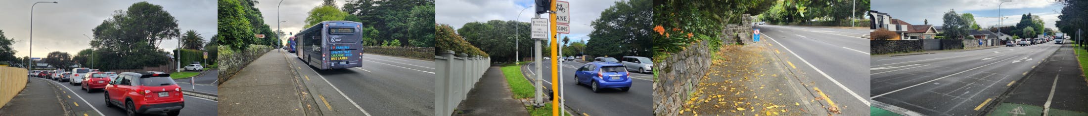
Greenlane is one of Auckland’s busiest and fastest-growing areas, home to parks, schools, housing, and major events. Green Lane West carries about 25,000 vehicles daily and 70,000 bus trips in peak months, but congestion slows traffic to 15 – 20 km/h at rush hour. Buses run every 15 minutes, and cycling is possible, though space is tight.
Making the most of the space on this corridor while aiming to move everyone safely through this road is a challenge we have taken. We’re proposing changes for better bus reliability, safer walking and cycling, and a layout that works as the community grows - take a look at our proposal below for more details.
- Bus lanes in both directions between St Andrews Road and Manukau Road from 7–10 am and 3 – 6 pm on weekdays (Monday to Friday). These lanes will use the current parking spaces during peak hours to make the road more efficient. Outside these times, the space will still be available for parking.
- A T2 lane from 7–10 am heading east towards Great South Road and 3 – 6 pm heading west away from Great South Road on weekdays (Monday - Friday). We plan to convert one general traffic lane into a T2 lane because this section has limited road space.
- Where possible, we are proposing to narrow the flush median and widen the on-road cycle lanes to provide safer cycling facilities. We are also proposing a new shared path where the footpath is wide enough to accommodate both pedestrians and cyclists and the road is too narrow to provide a safe on-road facility.
- Upgrading the pedestrian refuge islands to signalised pedestrian crossings near Auckland Showgrounds and near Cornwall Park so pedestrians can cross safely without having to navigate through two lanes of busy traffic on each side of the road.
- Remove the existing pedestrian refuge island outside Cornwall Park District School as it creates a safety risk by leading directly into the school’s parking area and driveway. People will be redirected to use the nearby crossing at the Wheturangi Road intersection.
- Reposition bus stops within the traffic lane. Buses currently move in and out of the traffic lane to pick up and drop off passengers. We are repositioning them closer to the traffic lane for smoother bus movements.
- Add two new cycle crossings - one near Manukau Road and another near Wheturangi Road to give cyclists safe places to cross and continue their journey.

How you can have your say
We’d like to hear your thoughts on how we can refine our plans to help you move safely along this road. Please provide your feedback by taking this survey by 19 December 2025.
You can also come and have a chat to us in-person (details below), or email your feedback to ATEngagement@at.govt.nz(External link).
| Date/time | Venue |
| Wednesday, 26 November from 5:00 - 7:00 pm | Cornwall Park District School (CPDS) |
| Sunday, 07 December from 10:00 am - 12:00 pm | Cornwall Park café by the rotunda |
About the Network Optimisation Programme
Auckland's future travel demand will largely rely on making the best of our existing transport corridors. The Auckland Network Optimisation Programme aims to enhance the city's transport network. By making small, cost-effective changes to roads and paths, the programme seeks to improve travel choices, road safety, and overall efficiency. Find out more about how we optimise our transport network here(External link).
