Shirley Road and Dreadon Avenue Intersection Improvement
Shirley Road and Dreadon Avenue Intersection Improvement
Engagement Summary
Thank you for helping us make better decisions for your neighbourhood, informed by your local knowledge.
Community feedback showed support for the safety intent of the project, while some respondents also raised suggestions or concerns. These matters have been reviewed and are addressed below.
Project outcome
After carefully reviewing the feedback we received, the current Auckland Council recommendation is to proceed with the project as proposed. The project will then progress through the required approval process before construction can begin. If approvals progress as expected, we anticipate these changes be implemented by mid-2027.
What we did
Engagement was held from 18 May 2026 to 10 June 2026.
- 1056 letters delivered to mailboxes on 18 May 2026
- 800 postcards delivered to businesses and properties in the proposal area on 19 May 2026
- Auckland Council social media
- Auckland Council project webpage: https://haveyoursay.at.govt.nz/shirley-and-dreadon
- Emails to stakeholders including emergency services, freight operators, NZ Police and schools
- Ōtara-Papatoetoe Local Board was updated by email on 11 May 2026, followed by a workshop on 11 August 2026.
- On-site meetings with the key stakeholders on 9 June 2026, 17 September 2026 and 30 September 2026.
We received 16 pieces of feedback.
Community Feedback
People told us:
- The proposed signalised intersection and pedestrian crossings are supported by residents. The current intersection is considered unsafe by many members of the community, particularly for right-turning vehicles exiting Dreadon Avenue onto Shirley Road. These safety improvements are needed for pedestrians, especially elderly residents, or those with disabilities.
Feedback themes and AT response – Local Community
|
Support the proposal |
Respondents supported the proposed signalised intersection as a necessary improvement to control the traffic flow, provide safe crossing points for vulnerable users and reduce crash risk. Response: Thank you for your feedback.
|
Traffic flow and congestion |
Some respondents raised concerns that the proposed traffic signals may reduce traffic flow efficiency and increase queuing. Comment also suggested that the signal may generate a problem elsewhere with increased congestion at the Great South Road / Shirley Road intersection. Response: We understand that traffic queues already occur in this area, particularly because of the traffic signals on Great South Road. At times, these queues can extend through the intersection. The proposed new signals may add some delay for people travelling on Shirley Road; however, our traffic modelling shows that this delay is expected to be manageable and is not likely to cause significant congestion or major impacts on the surrounding road network. The main purpose of this project is to improve safety at the intersection, particularly for people turning into and out of Dreadon Avenue, by providing safer and more controlled movements for all road users.
|
Pedestrian Safety & Crossing Design |
Some respondents raised concerns that installing traffic signals at this location could create safety risks for children playing nearby, particularly if the changes result in erratic driver behaviour. Some respondents suggested alternative crossing arrangements, like a central berm as a refuge or pedestrian facilities incorporated into a roundabout. Response: We understand the concern about more people, including children, crossing Shirley Road. People are already crossing in this area, and the proposed signalised pedestrian crossing is intended to give them a safer and more accessible place to cross. The signals would give pedestrians a dedicated crossing time and require drivers to stop when the signals indicate, helping to make movements through the intersection more predictable. This is expected to improve safety for pedestrians, drivers, and other road users, particularly children and more vulnerable people.
|
Physical Environment |
Some respondents raised concerns about potential effects on the local environment. Both respondents commented on noise and vehicle emissions associated with stopping, starting or idling traffic. Comment also raised concerns about traffic signal glare, engine vibrations and potential privacy effects. Response: The proposed traffic signals and pedestrian crossings would be located within the existing road corridor and are not expected to materially alter the local environment. We understand concerns about light, noise, vibration, vehicle emissions and privacy. While some vehicles may brake and accelerate at the signals, this is expected to be similar to what already occurs in the area because of queues from the Great South Road signals. The proposal does not include traffic calming measures or major road surface changes that would be expected to create additional vibration effects. Any additional light and noise would be limited to the normal operation of the traffic signals, such as signal lights for drivers and pedestrian crossing sounds when the crossing button is pressed for the visually impaired pedestrians.
|
Road layout improvements |
Some respondents suggested changing the Dreadon Avenue layout to allow left-turn-in and left-turn-out movements only. Some respondents suggested replacing the proposed traffic signals with a roundabout and providing pedestrian crossing facilities. Response: We considered these options during the investigation stage. Changing Dreadon Avenue to allow left turns only would mean people could no longer turn right into or out of Dreadon Avenue. This would divert more than 1,000 vehicle movements each day to other intersections. We consider this would have a significant impact on the local community, as drivers would need to detour to either the Coronation Road roundabout or the Kolmar Road signals to access Great South Road or Dreadon Avenue. We also assessed the roundabout option. Traffic modelling showed that a roundabout would have limited spare capacity and may not be able to support future traffic demand or growth in the area, particularly during the afternoon peak. For these reasons, the left-turn-only and roundabout options are not preferred. The proposed signalised option is considered to provide a better balance between improving safety, maintaining access, and managing traffic movements through the area.
|
Cost concerns and alternatives |
Some respondents raised concerns about the cost or value for money of the project. Comments suggested that AT should prioritise resources elsewhere, including requests for maintenance improvements at Omana Park. Response: We understand concerns about the cost of the project and how public funding is prioritised. This intersection has been identified as a high-risk location and is one of the higher-risk intersections in the Ōtara-Papatoetoe Local Board area, currently ranked 11th. The project is funded through Auckland Transport’s Road Safety Programme, which focuses on improving locations where there is a higher risk of crashes and where safety improvements can help reduce the likelihood of people being seriously injured. We also acknowledge the comments about Omana Park. Maintenance and improvements at Omana Park are managed by Auckland Council and are funded separately from Auckland Transport’s road safety budget. This means funding allocated for road safety improvements cannot be directly transferred to park maintenance. The proposed intersection improvements are being considered because of the safety risk identified at this location.
|
Parking & Access |
Some submissions raised concerns about the loss of on-street parking. Respondents raised concerns about customer, accessibility or driveway access and requested additional parking restrictions, yellow lines or no-stopping markings. Submissions noted that existing parked vehicles restrict visibility or traffic flow. Comment suggested modifying the berm area to provide space for vehicles to park safely. Some submissions raised potential property-value impacts. Response: We understand concerns about the potential loss of on-street parking and the impact this may have on nearby residents and businesses. The proposed broken yellow lines, which mean no stopping, are needed to keep the area near the intersection clear so drivers can see the new traffic signals, pedestrians and other road users. Clear visibility is important for the signals to operate safely. Although broken yellow lines are not currently marked in this location, parking is already restricted near intersections under the Land Transport (Road User) Rule 2004. The proposed markings would make these existing restrictions clearer and easier for drivers to follow. We have also considered the suggestion to allow berm-side parking, however, parking close to the intersection could affect visibility and the safe operation of the new signals. Some on-street parking would still be available nearby on Dreadon Avenue. For these reasons, the proposed broken yellow lines are proposed to support safer movements for drivers, pedestrians and other road users.
|
Need and suitability of traffic signals |
Some submissions questioned the need, location or suitability of traffic signals and some referred to their proximity to the Great South Road / Shirley Road signals. Some respondents considered signals excessive for a smaller side street or standard section of road. Response: We understand the concerns about whether traffic signals are the right treatment for this location, particularly given the nearby signals at Great South Road and the traffic volumes on Dreadon Avenue. The main purpose of this project is to address the safety risk associated with vehicles turning into and out of Dreadon Avenue. During the investigation stage, we considered several options, including restricting turning movements, installing signals and providing a roundabout. Restricting right turns would divert more than 1,000 vehicle movements each day to nearby intersections. We consider this would have a significant impact on the local community, as drivers would need to detour to either the Coronation Road roundabout or the Kolmar Road signals to access Great South Road or Dreadon Avenue. A roundabout was also assessed, but traffic modelling showed it would have limited spare capacity and may not support future traffic demand, particularly during the afternoon peak. The proposed signalised option is considered to provide the best balance between improving safety, maintaining access to Dreadon Avenue, and managing traffic movements through the area. The new signals would be about 250 metres from the existing Great South Road / Shirley Road signals, and this spacing has been considered as part of the design. Traffic modelling indicates that the proposed signals are expected to operate at an acceptable level and support the intended safety and traffic outcomes.
|
Queue-related driver behaviour and safety |
Some respondents raised concerns about unsafe or unpredictable driver behaviour and the potential safety risks associated with traffic queuing near the intersection. Response: We understand the concern that queues near the intersection could make it harder for drivers to exit nearby properties and merge safely into traffic. Traffic queues already occur in this area at times, particularly because of the nearby Great South Road signals. The proposed signalised intersection is intended to provide clearer control of vehicle movements and reduce conflict points at the intersection. Because the new signals would be located near the existing Great South Road signals, there is an opportunity to coordinate the signal timing to help traffic move through the area as smoothly and safely as possible. Traffic modelling indicates that the proposed signals are expected to operate at an acceptable level. While unsafe or unpredictable driver behaviour cannot be completely eliminated, the proposed signals would provide a more controlled and predictable road environment for drivers, pedestrians and other road users. Signal phasing and timing can also be reviewed and adjusted after installation if needed.
|
What happens next
After carefully reviewing the feedback we received, the current Auckland Council recommendation is to proceed with the project as proposed. The project will then progress through the required approval process before construction can begin. If approvals progress as expected, we anticipate these changes will be implemented by mid-2027.
We'll be in touch with residents in the affected work areas before construction begins.
About the project
Safety Improvements at the Shirley Road and Dreadon Avenue intersection
We are proposing to enhance safety at high‐risk intersections throughout Auckland.
This project aims to improve safety at the Shirley Road and Dreadon Avenue intersection, a high-risk site under Auckland Transport’s High-Risk Intersections Programme which ranked 11th in the Ōtara-Papatoetoe Local Board Area. There were 16 reported crashes between 2019 and 2025, including seven injury crashes, mostly involving vehicles entering or exiting Dreadon Avenue failing to give way to traffic on Shirley Road. The intersection also lacks pedestrian crossing facilities, and the proposed improvements are expected to reduce crash risk and improve safety for all road users.
What we’re planning to do before June 2027
We are proposing the following safety upgrades at the Shirley Road and Dreadon Avenue intersection:
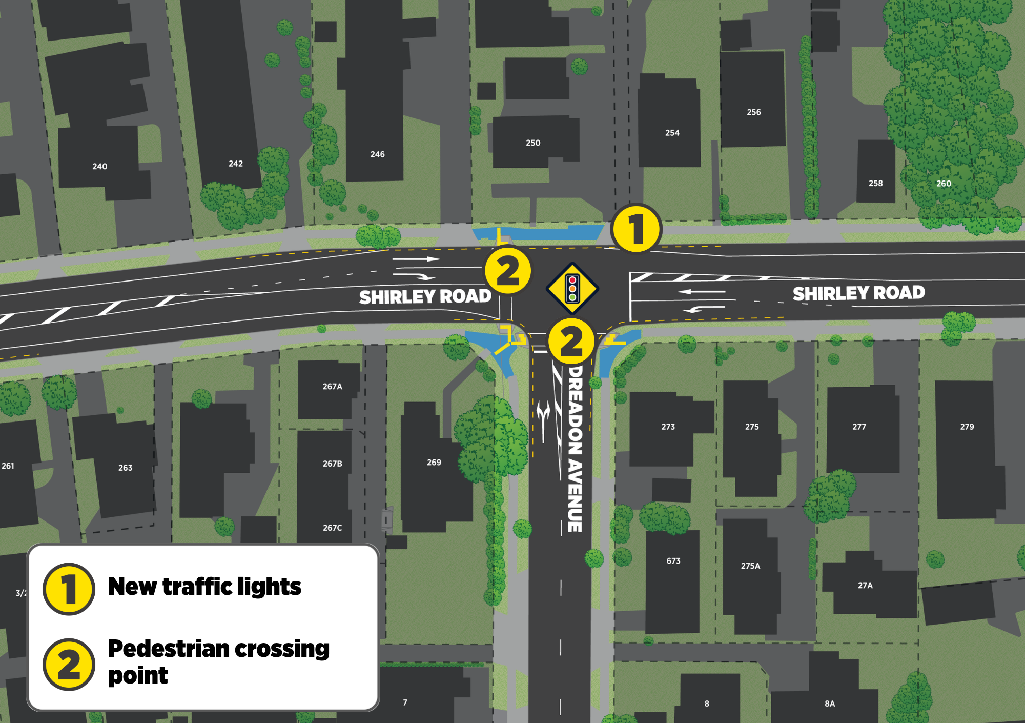
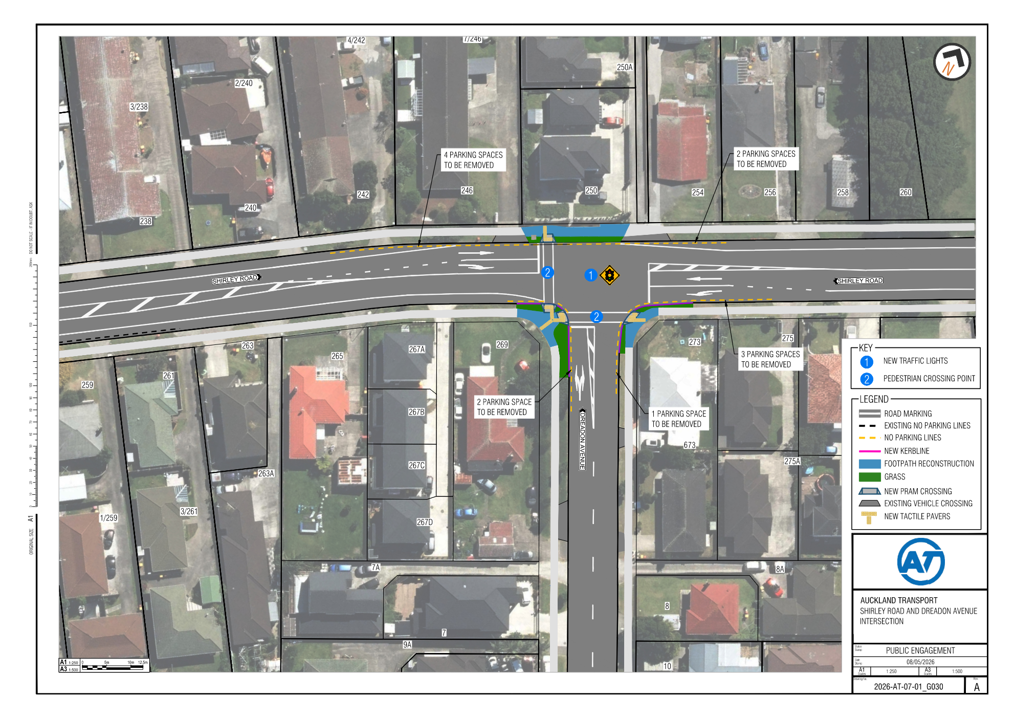
- Install traffic lights and create new pedestrian crossings on the west leg of Shirley Road and Dreadon Avenue.
- Reconstruct the footpath and grass berm where necessary.
- Improve the road surface, signs, and road markings where needed.
- Install broken yellow lines (No Stopping At All Times) to support these safety improvements.
- As a result, 12 parking spaces from the surrounding area will be removed. This includes the following changes:
- Remove 6 parking spaces outside 242 - 254 Shirley Road
- Remove 3 parking spaces outside 273 - 275 Shirley Road
- Remove 2 parking spaces outside 269 Shirley Road on Dreadon Avenue
- Remove 1 parking space outside 273 Shirley Road on Dreadon Avenue
You can view the proposed layout in the attached plan.
How this will benefit your neighbourhood
These improvements will make the intersection safer and more convenient for everyone, whether you’re driving, or walking.
- Better traffic flow for vehicles to move through the area
- Safer and easier to turn at the intersection
- Safer and more accessible crossing points for people walking
- A clearer and safer road layout for the community
Overall, the project will improve safety for all users, making it easier to use and better connected for everyone living, working, studying or visiting nearby.