About the project
With the growth in housing and jobs in the wider Māngere area, more people will be moving around the streets to get to where they want to go.
As more people move around the area, some changes are necessary to give more travel options for people wanting to bike or walk to work, school, local shops, church, and other important places.
New safe cycling routes through Māngere East and Favona are being proposed to give people more ways to get to important places. These include sports fields at Māngere Centre Park, shops at Māngere Town Centre, David Lange Park, and schools and churches along the way. The changes also set up important connection points for future bike links all the way to Māngere Bridge, Ōtāhuhu, and Middlemore.
This route has been developed with public feedback from a 2022 consultation. Public consultation was held again in 2025 to gather feedback on the proposed design for the route.
You can read the full Public Consultation Feedback Report here.
What did we hear from the community?
238 people gave feedback in the public survey. Of those people:
● Almost three-quarters (72%) live in areas surrounding the proposed bike route – in Favona, Māngere East, Māngere or Māngere Bridge.
● The majority (68%) currently travel through the area as drivers.
● 74% said they or their whānau would be likely or very likely to use the shared path and cycleway if built.
● There was strong support for future bike links in the area to both Ōtāhuhu and Papatoetoe (via Middlemore).
● The majority selected or suggested one or more benefits to the proposal.
● 5% raised concerns with specific elements of the proposed design.
● 6% questioned whether the project is needed.
What happens next?
The project is now moving through detailed design. During this stage, we may refine some details, including parking changes, as we complete further technical work and look for ways to improve safety.
Our next steps are to:
● Consider public feedback received in consultation.
● Continue to engage with key stakeholders.
● Confirm final design and parking changes
● Keep the community updated using various local channels.
Future updates about this project, including more information about the final design, parking changes and construction timing when available, will be published on our Māngere cycling and walking projects webpage.
You can also find information there about other connected walking and cycling projects across Māngere.
Find out more about the 2025 proposal below.
Video introducing the Māngere to Favona Link.
What is being proposed?
The proposed changes include:
A separated, two-way cycleway on Robertson Road connecting with the existing cycleway next to Māngere Centre Park.
A shared path for people on bikes and pedestrians along Wakefield Road and the southern part of Harania Avenue.
A new shared path through the greenspace in the southern section of Harania Creek.
Sharrow markings (where vehicles and people riding bikes share the lane) on the north end of Tennessee Avenue, before Vine Street.
Together, these changes extend the cycle network and provide the first part of new cycling connections between suburbs, making it easier to get to key local destinations by bike.
Click to view the 2025 Consultation Design Plan ( This is not the final design )
This plan shows the proposed design shared during public consultation in 2025. It is not the final design, and some details may change as the project progresses through detailed design. We expect to publish the final design later in 2026.
What are the benefits?
A new, safe off-road space for people to get comfortable riding a bike locally.
New walking and cycling connections for people on the streets surrounding Harania Creek and through Lenore Foreshore Reserve.
Easier and safer travel by bike between Māngere Town Centre, Māngere Centre Park, and Favona.
Sets up the connection points for future network links to Middlemore Hospital and Ōtāhuhu.
Links people on bikes to places along the wider Māngere cycle network, including in Māngere West, Māngere Bridge and the airport.
Make our streets better for all kinds of travel and help ensure young people have more freedom to get around now and in the future.
Two-way cycleway on Robertson Road

Robertson Road cycleway near Koru School.
The proposal includes a new two-way cycleway on Robertson Road, from the Wakefield Road intersection and connecting to the existing cycleway next to Māngere Centre Park on Robertson Road.
A two-way, protected cycleway on one side of the road will allow people on bikes to travel safely in both directions.
This section will connect directly to the existing bike paths through Māngere Centre Park, heading towards Māngere West and bike paths leading to Māngere Town Centre, making travel between them easier and safer for people on bikes.
Alongside the two-way cycleway, the bus stops will be upgraded. Stop 6953 will be relocated outside Koru School. The bus stops on Robertson Road will remain in-lane.
New crossings for pedestrians and people riding bikes between the new paths.
 Crossing on Robertson Road near Wakefield Road.
This proposal also includes three new crossings connecting the paths on the route. These paired crossings will prioritise people walking and cycling and provide a safe way to cross the streets.
One new paired crossing will connect people using the Harania Avenue shared path to the Harania Creek shared path.
A new paired crossing connecting the two-way cycleway on Robertson Road and the shared path on Wakefield Road.
A new paired crossing on Tennessee Avenue, near the Vine Street intersection.
Wakefield Road and Harania Avenue Shared Path.

Wakefield Road shared path near Favona School.
This proposal also includes a new shared path along Wakefield Road and the southern section of Harania Avenue, passing outside Favona School.
This will widen the current footpath to a 4-metre-wide shared path, allowing people to walk and cycle in both directions safely.
Shared paths are welcoming to beginners. They provide a safe space for everyone, especially tamariki, to grow their skills and confidence on bikes.
Harania Creek Shared Path.
 Harania Creek Shared Path connects with the existing pathway.
 This part of the proposal is to create a new shared path in the greenspace around Harania Creek. This will be an off-road space and create a new place for people to gain confidence on bikes.
The new shared path will be 3 metres wide, allowing space for people walking and biking to travel safely in both directions.
Paths joining the Harania Creek Shared Path to surrounding streets will reduce travel times for people walking and cycling between Mary Place, Harania Avenue, Opawa Cresent, Gadsby Road, Peachwood Grove, Parkstone Place, Archboyd Street, Bicknell Road, and Tennessee Avenue.
The path will also connect with the planned Blake Road footbridge, which is part of the Auckland Council Healthy Waters Project.
What are the trade-offs?
Creating more space on our streets for people to travel in different ways means making some trade-offs. The project aims to minimise the impacts of the design while keeping access for all kinds of journeys.
The majority of the proposal is shared paths, both on and off-road, which helps reduce the impact on parking. Some parking changes will be needed to provide:
- the two-way separated cycleway, shared path and crossings on Robertson Road
- a new pedestrian crossing on Harania Avenue
- a new raised crossing at the Cardrona Place and Wakefield Road intersection
- bus stop and intersection safety improvements.
- On Robertson Road, parking changes apply only within the project area, not along the full length of the road.
- 12 parking spaces will remain within the Robertson Road project area.
- The length of flush medians on Robertson Road will be reduced. The flush medians (painted area in the middle of the road where drivers can wait to turn right) will be kept around side streets and Koru School.
These changes are needed to provide better visibility and to make it safer for people walking, cycling, wheeling, using public transport and driving through the area.
We are confirming the final parking changes and will update this page when this information is available.
What else are we doing?
This project is one step towards creating a Māngere where people can get around however they want, including by bike.
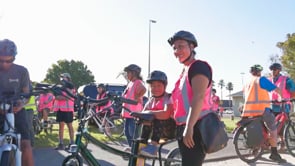
People in Māngere have told us that they need more than safer, more connected cycle routes to feel confident giving cycling a go. That’s why Auckland Transport has been working closely with local community groups to help more people gain the skills, resources and confidence to get around by bike. Programmes already delivered in Māngere have included bike skills and safety training, group rides and e-bike trials.
About the project
With the growth in housing and jobs in the wider Māngere area, more people will be moving around the streets to get to where they want to go.
As more people move around the area, some changes are necessary to give more travel options for people wanting to bike or walk to work, school, local shops, church, and other important places.
New safe cycling routes through Māngere East and Favona are being proposed to give people more ways to get to important places. These include sports fields at Māngere Centre Park, shops at Māngere Town Centre, David Lange Park, and schools and churches along the way. The changes also set up important connection points for future bike links all the way to Māngere Bridge, Ōtāhuhu, and Middlemore.
This route has been developed with public feedback from a 2022 consultation. Public consultation was held again in 2025 to gather feedback on the proposed design for the route.
You can read the full Public Consultation Feedback Report here.
What did we hear from the community?
238 people gave feedback in the public survey. Of those people:
● Almost three-quarters (72%) live in areas surrounding the proposed bike route – in Favona, Māngere East, Māngere or Māngere Bridge.
● The majority (68%) currently travel through the area as drivers.
● 74% said they or their whānau would be likely or very likely to use the shared path and cycleway if built.
● There was strong support for future bike links in the area to both Ōtāhuhu and Papatoetoe (via Middlemore).
● The majority selected or suggested one or more benefits to the proposal.
● 5% raised concerns with specific elements of the proposed design.
● 6% questioned whether the project is needed.
What happens next?
The project is now moving through detailed design. During this stage, we may refine some details, including parking changes, as we complete further technical work and look for ways to improve safety.
Our next steps are to:
● Consider public feedback received in consultation.
● Continue to engage with key stakeholders.
● Confirm final design and parking changes
● Keep the community updated using various local channels.
Future updates about this project, including more information about the final design, parking changes and construction timing when available, will be published on our Māngere cycling and walking projects webpage.
You can also find information there about other connected walking and cycling projects across Māngere.
Find out more about the 2025 proposal below.
Video introducing the Māngere to Favona Link.
What is being proposed?
The proposed changes include:
A separated, two-way cycleway on Robertson Road connecting with the existing cycleway next to Māngere Centre Park.
A shared path for people on bikes and pedestrians along Wakefield Road and the southern part of Harania Avenue.
A new shared path through the greenspace in the southern section of Harania Creek.
Sharrow markings (where vehicles and people riding bikes share the lane) on the north end of Tennessee Avenue, before Vine Street.
Together, these changes extend the cycle network and provide the first part of new cycling connections between suburbs, making it easier to get to key local destinations by bike.
Click to view the 2025 Consultation Design Plan ( This is not the final design )
This plan shows the proposed design shared during public consultation in 2025. It is not the final design, and some details may change as the project progresses through detailed design. We expect to publish the final design later in 2026.
What are the benefits?
A new, safe off-road space for people to get comfortable riding a bike locally.
New walking and cycling connections for people on the streets surrounding Harania Creek and through Lenore Foreshore Reserve.
Easier and safer travel by bike between Māngere Town Centre, Māngere Centre Park, and Favona.
Sets up the connection points for future network links to Middlemore Hospital and Ōtāhuhu.
Links people on bikes to places along the wider Māngere cycle network, including in Māngere West, Māngere Bridge and the airport.
Make our streets better for all kinds of travel and help ensure young people have more freedom to get around now and in the future.
Two-way cycleway on Robertson Road
Robertson Road cycleway near Koru School.
The proposal includes a new two-way cycleway on Robertson Road, from the Wakefield Road intersection and connecting to the existing cycleway next to Māngere Centre Park on Robertson Road.
A two-way, protected cycleway on one side of the road will allow people on bikes to travel safely in both directions.
This section will connect directly to the existing bike paths through Māngere Centre Park, heading towards Māngere West and bike paths leading to Māngere Town Centre, making travel between them easier and safer for people on bikes.
Alongside the two-way cycleway, the bus stops will be upgraded. Stop 6953 will be relocated outside Koru School. The bus stops on Robertson Road will remain in-lane.
New crossings for pedestrians and people riding bikes between the new paths.
Crossing on Robertson Road near Wakefield Road.
This proposal also includes three new crossings connecting the paths on the route. These paired crossings will prioritise people walking and cycling and provide a safe way to cross the streets.
One new paired crossing will connect people using the Harania Avenue shared path to the Harania Creek shared path.
A new paired crossing connecting the two-way cycleway on Robertson Road and the shared path on Wakefield Road.
A new paired crossing on Tennessee Avenue, near the Vine Street intersection.
Wakefield Road and Harania Avenue Shared Path.
Wakefield Road shared path near Favona School.
This proposal also includes a new shared path along Wakefield Road and the southern section of Harania Avenue, passing outside Favona School.
This will widen the current footpath to a 4-metre-wide shared path, allowing people to walk and cycle in both directions safely.
Shared paths are welcoming to beginners. They provide a safe space for everyone, especially tamariki, to grow their skills and confidence on bikes.
Harania Creek Shared Path.
Harania Creek Shared Path connects with the existing pathway. This part of the proposal is to create a new shared path in the greenspace around Harania Creek. This will be an off-road space and create a new place for people to gain confidence on bikes.
The new shared path will be 3 metres wide, allowing space for people walking and biking to travel safely in both directions.
Paths joining the Harania Creek Shared Path to surrounding streets will reduce travel times for people walking and cycling between Mary Place, Harania Avenue, Opawa Cresent, Gadsby Road, Peachwood Grove, Parkstone Place, Archboyd Street, Bicknell Road, and Tennessee Avenue.
The path will also connect with the planned Blake Road footbridge, which is part of the Auckland Council Healthy Waters Project.
What are the trade-offs?
Creating more space on our streets for people to travel in different ways means making some trade-offs. The project aims to minimise the impacts of the design while keeping access for all kinds of journeys.
The majority of the proposal is shared paths, both on and off-road, which helps reduce the impact on parking. Some parking changes will be needed to provide:
- the two-way separated cycleway, shared path and crossings on Robertson Road
- a new pedestrian crossing on Harania Avenue
- a new raised crossing at the Cardrona Place and Wakefield Road intersection
- bus stop and intersection safety improvements.
- On Robertson Road, parking changes apply only within the project area, not along the full length of the road.
- 12 parking spaces will remain within the Robertson Road project area.
- The length of flush medians on Robertson Road will be reduced. The flush medians (painted area in the middle of the road where drivers can wait to turn right) will be kept around side streets and Koru School.
These changes are needed to provide better visibility and to make it safer for people walking, cycling, wheeling, using public transport and driving through the area.
We are confirming the final parking changes and will update this page when this information is available.
What else are we doing?
This project is one step towards creating a Māngere where people can get around however they want, including by bike.
People in Māngere have told us that they need more than safer, more connected cycle routes to feel confident giving cycling a go. That’s why Auckland Transport has been working closely with local community groups to help more people gain the skills, resources and confidence to get around by bike. Programmes already delivered in Māngere have included bike skills and safety training, group rides and e-bike trials.