Clevedon-Kawakawa Road Corridor Safety Improvements
Engagement Summary
Thank you for helping us make better decisions for your neighbourhood, informed by your local knowledge.
Community feedback showed support for the safety intent of the project, while some respondents also raised suggestions or concerns. These matters have been reviewed and are addressed below.
Project outcome
After carefully reviewing the feedback we received, we are proceeding with the project as proposed with one minor change. The driveway at 287 Clevedon-Kawakawa Road will not be sealed.
We expect to have these changes implemented by mid-2027.
What we did
Engagement was held from 8 July 2026 to 22 July 2026.
- 611 letters delivered to mailboxes on 8 July 2026
- AT project webpage: https://haveyoursay.at.govt.nz/clevedon-kawakawa
- Emails to stakeholders including emergency services, freight operators, NZ Police and schools
- Franklin Local Board received an email update on 7 July 2026
We received 10 pieces of feedback.
Community Feedback
People told us:
- The proposed safety improvements on Clevedon-Kawakawa Road are strongly supported. The current road condition is considered unsafe by many members of the community, and number of crashes have been witnessed. These safety improvements are needed for drivers, and people are welcoming more safety measures on Clevedon-Kawakawa Road.
Feedback themes and AT response |
Support the proposal |
Respondents supported the proposed safety measures as necessary improvements to control the traffic flow, provide safe crossing points for vulnerable users and reduce loss-of -control crash risk. Response: Thank you for your feedback. |
Poor road surface conditions |
Some respondents requested surface improvements at additional locations: near the Māori cemetery before the oyster farm; approximately 30 metres from 287 Clevedon-Kawakawa Road towards Clevedon; between 782–810 and 877–888; between 777–914; from the Holdens Road bend to 210; and between 351–377 Clevedon-Kawakawa Road. Several comments raised slippery-surface or traction concerns. Some respondents also described uneven or corrugated surfaces. Respondent reported truck noise caused by an uneven surface. Comment requested chip-seal surfacing for motorcycle traction. Response: Thank you for sharing your local knowledge and highlighting the areas where the road surface is in poor condition. In addition to the high-friction surfacing locations proposed for Clevedon-Kawakawa Road as part of this project, Auckland Transport has also scheduled road resealing work at the locations you identified, including: - 914-921 Clevedon-Kawakawa Road i.e. the Māori cemetery to Clevedon Coast Oysters
- 287 Clevedon-Kawakawa Road
- 782-810 Clevedon-Kawakawa Road
- 877-888 Clevedon-Kawakawa Road
- 351-377 Clevedon-Kawakawa Road
The remaining location is the section from the Holdens Road bend to 210 Clevedon-Kawakawa Road. Part of this section is already included in the current project, from Holdens Road to 102 Clevedon-Kawakawa Road. After the safety improvements are installed, we will continue to monitor the area and consider further safety measures if they are needed. |
Road shoulders and driveways |
Some respondents commented on gravel shoulders and driveways, including at 821, 590 and 272 Clevedon-Kawakawa Road, as well as more generally along the corridor. Several respondents raised concerns about loose gravel or gravel migration at 821 and 590 Clevedon-Kawakawa Road. Comments requested additional sealing at shoulders and driveways at 821 and 272 Clevedon-Kawakawa Road. Several respondents requested wider shoulders for slow traffic to pull over to give way if necessary. Response: The safety improvements proposed for Clevedon-Kawakawa Road have been prioritised based on our investigation findings. The current project focuses on locations where the road surface has lower skid resistance, and where gravel driveways or shoulders may be contributing to safety concerns, including reported loss-of-control crashes. The additional locations suggested, including 821, 590 and 272 Clevedon-Kawakawa Road are not currently prioritised at this stage. Once the planned safety improvements are in place, we will continue to monitor the area and consider further improvements if they are needed. |
Signs, markings and speed management |
Some respondents requested additional warning or driver-information signs, including curve-warning signs near Holdens Road and 196 Clevedon-Kawakawa Road. Respondent requested centreline rumble strips along the corridor. Respondent considered active warning signs unnecessary and questioned whether additional signs would influence speeding drivers. Response: We have reviewed Clevedon-Kawakawa Road as part of the Rural Delineation Programme. This safety programme focuses on improving road markings and signs, so they are consistent and easy for drivers to understand across the network. One suggestion was to replace the existing warning sign before Holdens Road with a “reverse curves” sign, similar to the proposed sign near 411 Clevedon-Kawakawa Road. We reviewed this location and note that the two bends near No. 157 and No. 196 are about 450 metres apart. Based on the relevant design guidance, a “reverse curves” sign is generally used where there are three or more curves close together and where separate signs for each curve would not be practical. At this location, there are only two bends, and each already has individual chevron boards and advisory speed signs. These signs are visible, clear and well maintained, so we do not consider a “reverse curves” sign to be the most suitable option here. To further highlight the bends and encourage safer speeds along the corridor, we are proposing active warning signs before two bends, one near 102 and the other near 411 Clevedon-Kawakawa Road. We will continue to monitor this corridor after the improvements are in place and will consider whether any further measures are needed, including the additional sign the respondent suggested near 196 Clevedon-Kawakawa Road. AT has also recently installed centreline rumble strips along the sections of Clevedon-Kawakawa Road where there is enough space to do so safely. These rumble strips provide tactile feedback to drivers if they cross over the centreline, helping to alert them and support safer driving. Active warning signs are an approved safety intervention and are recognised by NZTA as an effective way to make drivers more aware of curves ahead. By drawing attention to the road environment, these signs can help encourage safer speeds, with research showing they can reduce approach speeds to curves by up to 11 km/h. |
Drainage and Flooding |
Respondent raised concerns about gravel blocking drainage and water pooling outside 590 Clevedon-Kawakawa Road. Respondent requested that the road between 351–369 Clevedon-Kawakawa Road, west of Atchison’s Bridge, be raised to reduce floodwater flowing across the carriageway. Response: Thank you for raising these concerns. We have reviewed the locations identified and based on the available crash history and current risk assessment. They are not considered high-risk locations at this time. As a result, they are not currently prioritised for additional safety treatments under this project at this stage. We understand the importance of maintaining a safe and reliable road environment, and we will continue to monitor these locations as part of our ongoing network safety reviews. If future evidence shows an increased safety risk, we will consider whether further investigation or treatment is needed. |
Vulnerable Users and Roadside Protection |
Respondent requested wider shoulders for people walking and a galvanised steel roadside barrier at Whitford Point. Respondent requested safe shoulders for cyclists, suitable sightlines and chip-seal surfacing for motorcyclists, and asked that wire-rope barriers to be avoided. Response: We understand that additional shoulder space can provide more comfort and separation for people walking and cycling, particularly on rural roads. However, providing wider shoulders consistently along Clevedon–Kawakawa Road is generally challenging due to the existing road width, roadside constraints, property boundaries, drainage, topography, and the overall length of the corridor. As Clevedon–Kawakawa Road is a long route, it would be helpful to understand the specific locations where wider or safer shoulder space or chip-seal surfacing for motorists is considered most needed. This would allow Auckland Transport to better consider the request in context, including road width, visibility, roadside conditions, safety risk, and how any potential improvements could be prioritised alongside other network needs. Regarding the request for a galvanised steel roadside barrier at Whitford Point, and the request to avoid wire-rope barriers, Auckland Transport generally assesses roadside safety risks across the wider transport network to identify priority locations for further investigation and potential treatment. This network-wide approach helps ensure investment is directed to locations with the highest safety need, taking into account factors such as crash history, roadside hazards, traffic volumes, road geometry, available road width, and the likely effectiveness and suitability of different barrier types. Your feedback will be recorded and considered as part of future corridor investigations and programme prioritisation. |
Project Information and Engagement |
Respondent requested clearer landmarks on the plans to identify the proposed work locations. Respondent asked whether the proposal had been discussed with the local community association. Response: A plan showing clearer landmarks can be provided by contacting the project team. The local community association is being informed at the same time as this public information process. |
NZHHA / heavy haulage |
The Heavy Haulage Association was contacted as a stakeholder given the intersection's potential impact on heavy vehicle movements. They submitted a report which outlined their support for the project. Response: We responded that we acknowledge their submission and will let them know of the project outcome. |
What happens next
After carefully reviewing the feedback we received, we are proceeding with the project as proposed.
We expect to have these changes implemented by mid-2027.
We'll be in touch with residents in the affected work areas before construction begins.
About the project
- We are proposing to enhance safety at high‐risk bends along the Clevedon-Kawakawa Road Corridor.
- This project comprises a series of cost-effective measures proposed to enhance safety at high-risk bends along Clevedon-Kawakawa Road in Clevedon and Kawakawa Bay. These safety measures aim to reduce the risks associated with vehicle loss of control, ensuring drivers can safely navigate through these high-risk locations.
What we’re planning to do before June 2027
We are proposing one or more of the following safety interventions:
- Improve road surface on the approach to and through five bends to enhance the skid resistance. These are proposed at the following locations:
- Bend at the Holdens Road intersection
- Bend at the Ness Valley Road intersection
- Bend at 476 Clevedon-Kawakawa Road
- Bend between 659 and 661 Clevedon-Kawakawa Road
- Bend at 1331 Clevedon-Kawakawa Road
- Install Active Warning Signs (AWS) to encourage safe and appropriate speeds.
- 250m east from 102 Clevedon-Kawakawa Road (eastbound)
- 10m east from 411 Clevedon-Kawakawa Road (westbound)
- Remark existing road marking to guide motorists more effectively.
- Reseal the driveway and shoulders outside the following 14 properties to prevent gravel migration. Where feasible and necessary, the shoulders will also be widened.
- 262 Clevedon-Kawakawa Road
- 270 Clevedon-Kawakawa Road
- 287 Clevedon-Kawakawa Road
- 300 Clevedon-Kawakawa Road
- 390 Clevedon-Kawakawa Road
- 370 Clevedon-Kawakawa Road
- 410 Clevedon-Kawakawa Road
- 764 Clevedon-Kawakawa Road
- 782 Clevedon-Kawakawa Road
- 790 Clevedon-Kawakawa Road
- 800 Clevedon-Kawakawa Road
- 806 Clevedon-Kawakawa Road
- 810 Clevedon-Kawakawa Road
- 1168 Clevedon-Kawakawa Road
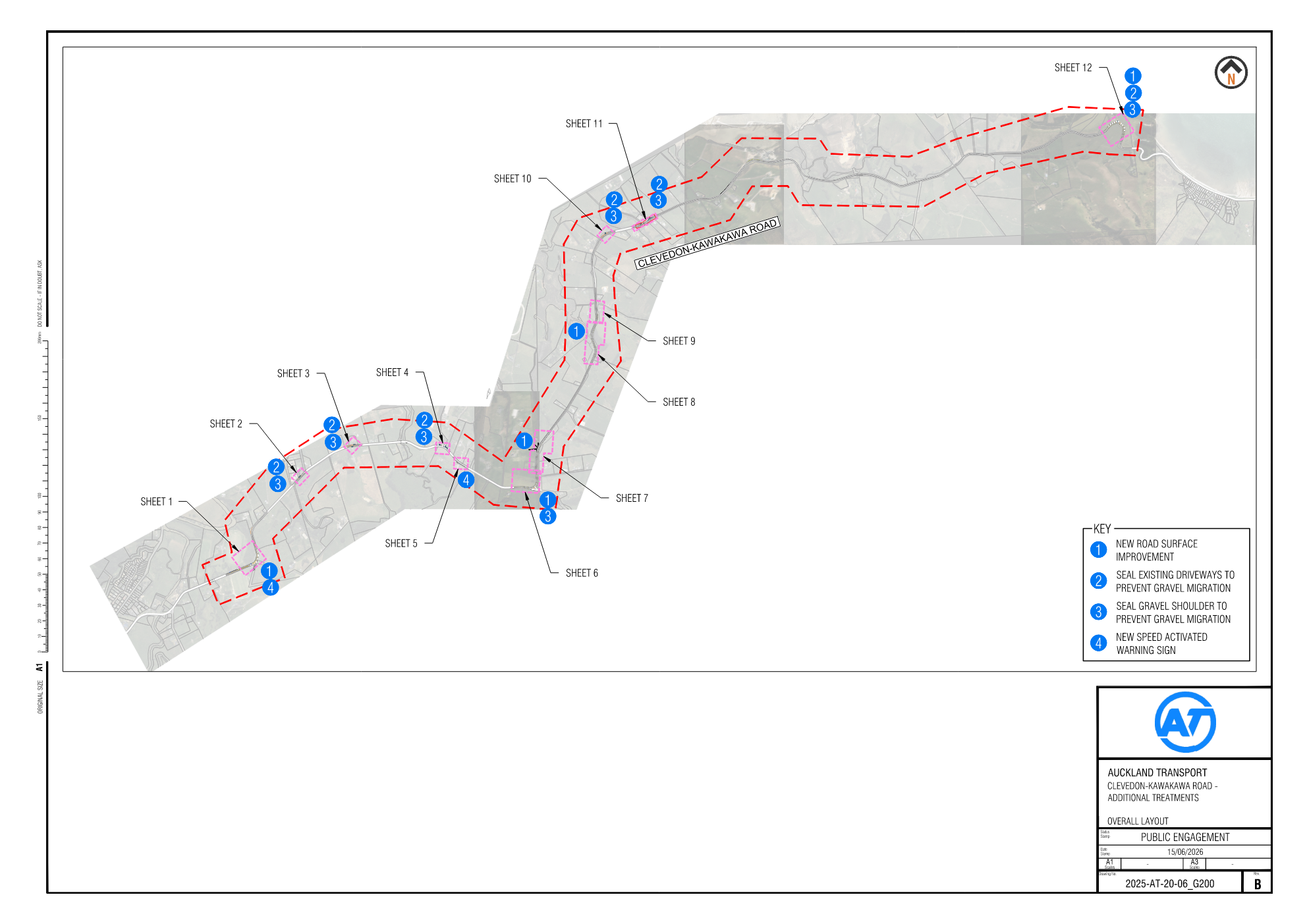
You can view the proposed layout in the attached plan.
How this will benefit your neighbourhood
These improvements will make the bends safer and more convenient for everyone.
- Better signage and road markings will help road users who are unfamiliar with this stretch of the road to drive to the conditions and manage their speed to travel through the tight curves safely.
- Improving the road surface will provide better grip and make the drive through safer and more comfortable.
Overall, the project will improve safety for all road users, making it easier to use and better connected for everyone living, working, studying or visiting nearby.
Clevedon-Kawakawa Road Corridor Safety Improvements
Engagement Summary
Thank you for helping us make better decisions for your neighbourhood, informed by your local knowledge.
Community feedback showed support for the safety intent of the project, while some respondents also raised suggestions or concerns. These matters have been reviewed and are addressed below.
Project outcome
After carefully reviewing the feedback we received, we are proceeding with the project as proposed with one minor change. The driveway at 287 Clevedon-Kawakawa Road will not be sealed.
We expect to have these changes implemented by mid-2027.
What we did
Engagement was held from 8 July 2026 to 22 July 2026.
- 611 letters delivered to mailboxes on 8 July 2026
- AT project webpage: https://haveyoursay.at.govt.nz/clevedon-kawakawa
- Emails to stakeholders including emergency services, freight operators, NZ Police and schools
- Franklin Local Board received an email update on 7 July 2026
We received 10 pieces of feedback.
Community Feedback
People told us:
- The proposed safety improvements on Clevedon-Kawakawa Road are strongly supported. The current road condition is considered unsafe by many members of the community, and number of crashes have been witnessed. These safety improvements are needed for drivers, and people are welcoming more safety measures on Clevedon-Kawakawa Road.
Feedback themes and AT response |
Support the proposal |
Respondents supported the proposed safety measures as necessary improvements to control the traffic flow, provide safe crossing points for vulnerable users and reduce loss-of -control crash risk. Response: Thank you for your feedback. |
Poor road surface conditions |
Some respondents requested surface improvements at additional locations: near the Māori cemetery before the oyster farm; approximately 30 metres from 287 Clevedon-Kawakawa Road towards Clevedon; between 782–810 and 877–888; between 777–914; from the Holdens Road bend to 210; and between 351–377 Clevedon-Kawakawa Road. Several comments raised slippery-surface or traction concerns. Some respondents also described uneven or corrugated surfaces. Respondent reported truck noise caused by an uneven surface. Comment requested chip-seal surfacing for motorcycle traction. Response: Thank you for sharing your local knowledge and highlighting the areas where the road surface is in poor condition. In addition to the high-friction surfacing locations proposed for Clevedon-Kawakawa Road as part of this project, Auckland Transport has also scheduled road resealing work at the locations you identified, including: - 914-921 Clevedon-Kawakawa Road i.e. the Māori cemetery to Clevedon Coast Oysters
- 287 Clevedon-Kawakawa Road
- 782-810 Clevedon-Kawakawa Road
- 877-888 Clevedon-Kawakawa Road
- 351-377 Clevedon-Kawakawa Road
The remaining location is the section from the Holdens Road bend to 210 Clevedon-Kawakawa Road. Part of this section is already included in the current project, from Holdens Road to 102 Clevedon-Kawakawa Road. After the safety improvements are installed, we will continue to monitor the area and consider further safety measures if they are needed. |
Road shoulders and driveways |
Some respondents commented on gravel shoulders and driveways, including at 821, 590 and 272 Clevedon-Kawakawa Road, as well as more generally along the corridor. Several respondents raised concerns about loose gravel or gravel migration at 821 and 590 Clevedon-Kawakawa Road. Comments requested additional sealing at shoulders and driveways at 821 and 272 Clevedon-Kawakawa Road. Several respondents requested wider shoulders for slow traffic to pull over to give way if necessary. Response: The safety improvements proposed for Clevedon-Kawakawa Road have been prioritised based on our investigation findings. The current project focuses on locations where the road surface has lower skid resistance, and where gravel driveways or shoulders may be contributing to safety concerns, including reported loss-of-control crashes. The additional locations suggested, including 821, 590 and 272 Clevedon-Kawakawa Road are not currently prioritised at this stage. Once the planned safety improvements are in place, we will continue to monitor the area and consider further improvements if they are needed. |
Signs, markings and speed management |
Some respondents requested additional warning or driver-information signs, including curve-warning signs near Holdens Road and 196 Clevedon-Kawakawa Road. Respondent requested centreline rumble strips along the corridor. Respondent considered active warning signs unnecessary and questioned whether additional signs would influence speeding drivers. Response: We have reviewed Clevedon-Kawakawa Road as part of the Rural Delineation Programme. This safety programme focuses on improving road markings and signs, so they are consistent and easy for drivers to understand across the network. One suggestion was to replace the existing warning sign before Holdens Road with a “reverse curves” sign, similar to the proposed sign near 411 Clevedon-Kawakawa Road. We reviewed this location and note that the two bends near No. 157 and No. 196 are about 450 metres apart. Based on the relevant design guidance, a “reverse curves” sign is generally used where there are three or more curves close together and where separate signs for each curve would not be practical. At this location, there are only two bends, and each already has individual chevron boards and advisory speed signs. These signs are visible, clear and well maintained, so we do not consider a “reverse curves” sign to be the most suitable option here. To further highlight the bends and encourage safer speeds along the corridor, we are proposing active warning signs before two bends, one near 102 and the other near 411 Clevedon-Kawakawa Road. We will continue to monitor this corridor after the improvements are in place and will consider whether any further measures are needed, including the additional sign the respondent suggested near 196 Clevedon-Kawakawa Road. AT has also recently installed centreline rumble strips along the sections of Clevedon-Kawakawa Road where there is enough space to do so safely. These rumble strips provide tactile feedback to drivers if they cross over the centreline, helping to alert them and support safer driving. Active warning signs are an approved safety intervention and are recognised by NZTA as an effective way to make drivers more aware of curves ahead. By drawing attention to the road environment, these signs can help encourage safer speeds, with research showing they can reduce approach speeds to curves by up to 11 km/h. |
Drainage and Flooding |
Respondent raised concerns about gravel blocking drainage and water pooling outside 590 Clevedon-Kawakawa Road. Respondent requested that the road between 351–369 Clevedon-Kawakawa Road, west of Atchison’s Bridge, be raised to reduce floodwater flowing across the carriageway. Response: Thank you for raising these concerns. We have reviewed the locations identified and based on the available crash history and current risk assessment. They are not considered high-risk locations at this time. As a result, they are not currently prioritised for additional safety treatments under this project at this stage. We understand the importance of maintaining a safe and reliable road environment, and we will continue to monitor these locations as part of our ongoing network safety reviews. If future evidence shows an increased safety risk, we will consider whether further investigation or treatment is needed. |
Vulnerable Users and Roadside Protection |
Respondent requested wider shoulders for people walking and a galvanised steel roadside barrier at Whitford Point. Respondent requested safe shoulders for cyclists, suitable sightlines and chip-seal surfacing for motorcyclists, and asked that wire-rope barriers to be avoided. Response: We understand that additional shoulder space can provide more comfort and separation for people walking and cycling, particularly on rural roads. However, providing wider shoulders consistently along Clevedon–Kawakawa Road is generally challenging due to the existing road width, roadside constraints, property boundaries, drainage, topography, and the overall length of the corridor. As Clevedon–Kawakawa Road is a long route, it would be helpful to understand the specific locations where wider or safer shoulder space or chip-seal surfacing for motorists is considered most needed. This would allow Auckland Transport to better consider the request in context, including road width, visibility, roadside conditions, safety risk, and how any potential improvements could be prioritised alongside other network needs. Regarding the request for a galvanised steel roadside barrier at Whitford Point, and the request to avoid wire-rope barriers, Auckland Transport generally assesses roadside safety risks across the wider transport network to identify priority locations for further investigation and potential treatment. This network-wide approach helps ensure investment is directed to locations with the highest safety need, taking into account factors such as crash history, roadside hazards, traffic volumes, road geometry, available road width, and the likely effectiveness and suitability of different barrier types. Your feedback will be recorded and considered as part of future corridor investigations and programme prioritisation. |
Project Information and Engagement |
Respondent requested clearer landmarks on the plans to identify the proposed work locations. Respondent asked whether the proposal had been discussed with the local community association. Response: A plan showing clearer landmarks can be provided by contacting the project team. The local community association is being informed at the same time as this public information process. |
NZHHA / heavy haulage |
The Heavy Haulage Association was contacted as a stakeholder given the intersection's potential impact on heavy vehicle movements. They submitted a report which outlined their support for the project. Response: We responded that we acknowledge their submission and will let them know of the project outcome. |
What happens next
After carefully reviewing the feedback we received, we are proceeding with the project as proposed.
We expect to have these changes implemented by mid-2027.
We'll be in touch with residents in the affected work areas before construction begins.
About the project
- We are proposing to enhance safety at high‐risk bends along the Clevedon-Kawakawa Road Corridor.
- This project comprises a series of cost-effective measures proposed to enhance safety at high-risk bends along Clevedon-Kawakawa Road in Clevedon and Kawakawa Bay. These safety measures aim to reduce the risks associated with vehicle loss of control, ensuring drivers can safely navigate through these high-risk locations.
What we’re planning to do before June 2027
We are proposing one or more of the following safety interventions:
- Improve road surface on the approach to and through five bends to enhance the skid resistance. These are proposed at the following locations:
- Bend at the Holdens Road intersection
- Bend at the Ness Valley Road intersection
- Bend at 476 Clevedon-Kawakawa Road
- Bend between 659 and 661 Clevedon-Kawakawa Road
- Bend at 1331 Clevedon-Kawakawa Road
- Install Active Warning Signs (AWS) to encourage safe and appropriate speeds.
- 250m east from 102 Clevedon-Kawakawa Road (eastbound)
- 10m east from 411 Clevedon-Kawakawa Road (westbound)
- Remark existing road marking to guide motorists more effectively.
- Reseal the driveway and shoulders outside the following 14 properties to prevent gravel migration. Where feasible and necessary, the shoulders will also be widened.
- 262 Clevedon-Kawakawa Road
- 270 Clevedon-Kawakawa Road
- 287 Clevedon-Kawakawa Road
- 300 Clevedon-Kawakawa Road
- 390 Clevedon-Kawakawa Road
- 370 Clevedon-Kawakawa Road
- 410 Clevedon-Kawakawa Road
- 764 Clevedon-Kawakawa Road
- 782 Clevedon-Kawakawa Road
- 790 Clevedon-Kawakawa Road
- 800 Clevedon-Kawakawa Road
- 806 Clevedon-Kawakawa Road
- 810 Clevedon-Kawakawa Road
- 1168 Clevedon-Kawakawa Road
You can view the proposed layout in the attached plan.
How this will benefit your neighbourhood
These improvements will make the bends safer and more convenient for everyone.
- Better signage and road markings will help road users who are unfamiliar with this stretch of the road to drive to the conditions and manage their speed to travel through the tight curves safely.
- Improving the road surface will provide better grip and make the drive through safer and more comfortable.
Overall, the project will improve safety for all road users, making it easier to use and better connected for everyone living, working, studying or visiting nearby.

